It’s that time again! The early November transition between the bright colors of the Autumn and the winter snow. Every November I also choose one mountain to call my “birthday hike”. I had decided to make this my birthday hike months ago while camping the islands of the Lower Saranac Lake. Years ago I had told myself I really wanted to get my feet to the top of McKenzie Mountain, but had never put this thought into action.

McKensie Mountain from Lake Flower 10/20/2013
McKenzie has been in the backdrop of many of my hiking, camping, and kayaking photos. It stands 3,861 feet between Saranac Lake and Lake Placid New York making it #55 of the Adirondack 100. McKenzie is not one of the highest mountains, nor does it have the most expansive views, but I was still giddy with anticipation to finally take the 5.3 mile hike to the summit.
My hiking partner and I couldn’t have asked for a more beautiful day. Blue sky, sunshine, and a crisp 24 degrees. the peaks were coated in white from a snowfall the night before. We started out from the trailhead at 8:15am.
The trail begins like many others. A gentle stroll through a mixed hardwood forest on a cushion of fallen leaves. We climbed gradually meandering around glacial erratics, over babbling brooks, and alongside a swiftly flowing creek. At 2.4 miles the blue blazed trail continues on to the left to reach Haystack (not the high peak), and the Red trail to the summit of McKenzie to the right.

The junction for Haystack and McKenzie
Just over one mile past the junction for Haystack, we met the junction for the jack-rabbit ski trail. Up until this point the trail has been a very pleasurable stroll through the woods. My memory recalls the trail becoming much less enjoyable. For about one mile we hopped from rock to rock to avoid landing in the thick mud and flowing water running down the eroded trail. With most of my hiking in the deeper part of winter, I had forgotten how much mud and rocks can effect a hike.
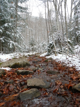
the wet, muddy, rock hop trail.
Where the mud stops, the trail gets real. Real steep that is. I didn’t track my route, but through reading other accounts, the steepest portion of the trail is about 1/2 mile long. From the jack-rabbit trail to the summit is about 1,300 feet in 1.7 miles. The wet, steep trail became increasingly icy as we scrambled up higher into the snow-covered trees. We strapped on our microspikes to tackle the icy ascent and continued scrambling along.

The steep, wet, icy, and beautiful trail.
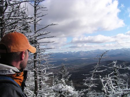
The suddenly steep climb brought us to our first vista back toward The Great range and regenerated our desire to reach the summit. We paused here for a moment to take in the sight. We stared off into the distance and for a short while we had forgotten the feeling in our legs, the mud on our feet, and the wet cold that had seeped through our gloves. Regenerated, we moved on.

The first open vista.
After another short bit of very steep trail, the path levels out over a false summit with the first view up toward the summit of McKenzie. Another half mile was all it would take to reach the top.
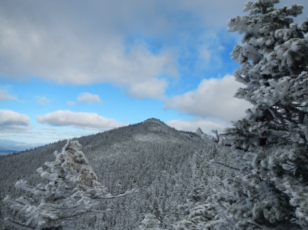
The summit of McKenzie from the false summit. It’s closer than it looks.
There is a drop between the false summit and the summit of McKenzie. From the top it appears to be a long steep descent, but turned out to be a very short drop with very little ice. The ascent was much more gradual than it appeared from the false summit as well. We reached the treed Summit at 1:15. There are two grand lookout points. One facing the Great Range with a bird’s-eye view of Lake Placid, and the other of the village of Saranac Lake with views of the chain of the Saranac Lakes, Oseetah, Flower, and Kiwassa.

the view of the great range and lake Placid.

The view of the Saranac Lakes chain, Oseetah, Kiwassa.
We had been slowed a bit by the mud and ice, and reached the summit a little later than we had anticipated. To be sure we made it back before dark, we relaxed for about a half hour, snapped photos, and devoured some food and water.
I couldn’t have asked for a better way to enjoy my birthday hike. Looking out over all of the waterways I have kayaked and across to the many other mountains I have summit over the years brought me a sense of accomplishment. I am a loss for words over how magical and awe-inspiring it is to look out from any summit of any mountain and gaze upon the majesty of the Adirondacks.